/
Edit: Editing, extracting and selecting points
Edit: Editing, extracting and selecting points
- Omar Lamrani
- Reza Mahmoudi Kuohi
- Solutions Geo-Plus (Unlicensed)
- Anonymous
Owned by Omar Lamrani
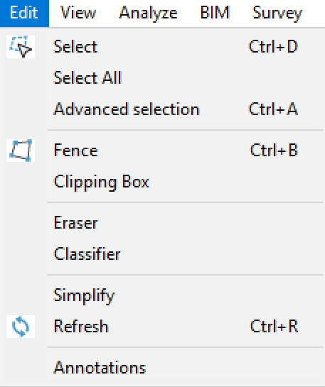
In this section certain concepts of segmenting, selecting and filtering the point cloud will be explained. Several tools within VisionLidar allow this type of manipulation.
- Select : This tool will let you manually select specific points.
- Select All : This tool will select all points from the point cloud and open the "Selection" window (see "Select"). If any points are hidden when this tool is activated, they will be displayed and selected.
- Advanced selection : This will open the ''Advanced selection'' window giving you access to additional tools to select points.
- Fence : This tool will let you create 2D fences
- Clipping Box : This tool will let you create 3D fences
- Eraser : Will open the "Eraser" window letting you hide some points without deleting them or have access to points beneath. These points can then be displayed again
- Classifier : Will open the the "Classifier" window allowing to promptly classify points using a cube or sphere as selection tool.
- Simplify : Will open the simplification window in order to reduce the number of points in your project.
- Refresh : Will refresh the point cloud display.
- Annotations : Will open the "Annotations" window allowing you to put annotations on the point cloud.
, multiple selections available,
Related content
Point cloud registration
Point cloud registration
Read with this
Editing, extracting and selecting points
Editing, extracting and selecting points
More like this
VisionLidar Pro
VisionLidar Pro
More like this
VisionLidar365 Release Notes v32.0
VisionLidar365 Release Notes v32.0
More like this
Fence
Fence
More like this
VisionLidar: User guide
VisionLidar: User guide
More like this